The Qing Dynasty was the last feudal dynasty in the history of our country and the second dynasty established by ethnic minorities. Its territory was second only to the Yuan Dynasty in its heyday, reaching 15 million square kilometers (excluding dependent countries).
The entrepreneurial history of the Qing Dynasty can be called inspirational. Since the establishment of Nurhachi in 1616, it took less than 180 years to reach its peak during the Qianlong period, and it has been growing. Today we have passed 6 maps of changes in Xinjiang , To see how the Qing Dynasty achieved great cause.
1. Map of East Asian situation in the middle and late Ming Dynasty

East Asian situation in the middle and late Ming Dynasty
In the middle and late Ming Dynasty, the northwestern Mongolia and the Northeast Jurchen , Is Ming’s main threat. The frequent intrusions and heavy military expenditures by the northern captives consumed the power of the Ming Dynasty.
2, Nurhachi period (1616-1626)
Situation in Nurhachi period
In 1616, Chinurhachi unified the Jurchen tribe, This is history For the first time, this also laid the foundation of the Qing dynasty . Under the leadership of Nurhachi, Jurchen continued to expand, established Houjin, rectified various Jurchen ministries and attacked the Liaodong area. became a bright threat to the Ming Dynasty.
In 1619, the Later Jin defeated the powerful Ming army with less victory in 萨尔浒战. Due to the great loss of military power, the offensive and defensive situation of Ming and Houjin in the northeast was reversed.
Saarhu War Route Map
3, Huangtaiji Period (1626-1643)
Huangtaiji Period Situation
皇太极两东征传说 made North Korea a subsidiary of the Qing Dynasty; three times 西征蒙林丹汗, Monan Mongolia (Inner Mongolia) was included in the Qing Dynasty territory; four times north Zheng东海女真, the Heilongjiang region was included in the territory of the Qing Dynasty. It can be seen to the naked eye that the territory of the Ming Dynasty continued to shrink and the territory of the Qing Dynasty gradually expanded.
Regarding the Ming Dynasty, Huang Taiji continued to attack the western region of Liaoning, causing the Ming Dynasty forces to completely withdraw from the northeast, with Shanhaiguan as the boundary.
皇太极
The son of Lin Danhan presented the so-called Central Plains dynasty "传国玉玺" , and Huang Taiji used this to announce the inheritance of Taoism and changed the national title to Qing in 1636. Officially proclaimed the emperor, and concurrently served as the Mongolian Empire Khan.
4. During the Shunzhi Emperor Period (1643-1661)
At this time, the Qing Dynasty, the area has reached more than 6 million square meters Kilometers, reaching the peak area of the Ming Dynasty.
In 1644, the Ming Dynasty was overthrown by a peasant uprising. Then there appeared in the inland separatist regimes such as Li Zicheng's "Dashun", Zhang Xianzhong's "Daxi" , Nanming and Zheng. Shunzhi succeeded to the throne, and the real power was in the hands of Dorgon. The Qing army took the opportunity to enter the customs. In 1644, they defeated Li Zicheng and established the capital of Beijing, declaring "Ding Ding Yanjing, Yi Sui China" .
The Qing Dynasty was not peaceful in the early days of the Central Plains. Enclosure orders, haircut orders, transfer laws, escape laws, customs prohibitions, and massacre were the eight major evils in the early Qing Dynasty.
5, Emperor Kangxi period (1661-1722)
Situation in Emperor Kangxi period
facing Emperor KangxiMany internal and external troubles have been solved one by one.
After Kangxi came to power, in 1681, the "San Francisco Rebellion" was put down and the situation on the mainland became more stable. The Zheng regime of Taiwan was eliminated in 1683, and the Taiwan government and the three counties of Taiwan, Fengshan, and Zhuluo were established in Taiwan, marking Taiwan's formal inclusion in the territory of the Central Plains dynasty in China.
Luo Tianxi--Zheng Chenggong regained Taiwan.
and then launched an external strategy: first attacked Tsarist Russia in the Northeast, regained the Heilongjiang River Basin, and passed the "Nevchu Treaty" ( 1689) Restricted the support of Tsarist Russia towards Gardan;
The Sino-Russian border stipulated in the Nibuchu Treaty
Then three conquered Gardan, defeated Junggar, and conquered desert Khalkha Mongol in the north (1697); in the southwest, the Junggar Mongol forces in Tibetan areas were expelled (1720), and the territory was greatly changed. The Qing Dynasty stationed troops in Qinghai-Tibet, marking that Tibet and Qinghai were included in the Qing Dynasty territory. Since then, the territory of the Qing Dynasty has exceeded 10 million square kilometers.
War between Qing Dynasty and Junggar
6, Yongzheng Emperor Period (1722-1735)
Yongzheng Emperor Situation
Yongzheng consolidated the country that was laid down by Kangxi. In the north, the "Blensky Treaty" and the "Kaktu Treaty" were signed with Russia, which established the Qing Dynasty's sovereignty over Mongolia; in the Qinghai-Tibet Plateau, the Lob Zangdanjin Rebellion was put down and the Xining Office Minister was set up And the Minister in Tibet, this is the first time that the Central Plains dynasty has set up an administrative agency on the Qinghai-Tibet Plateau. Change the land and return to current status"; aiming at the Gar side, forcing it to use the Altai Mountains as the boundary, and consolidating its rule over Mobei Khalkha Mongol.
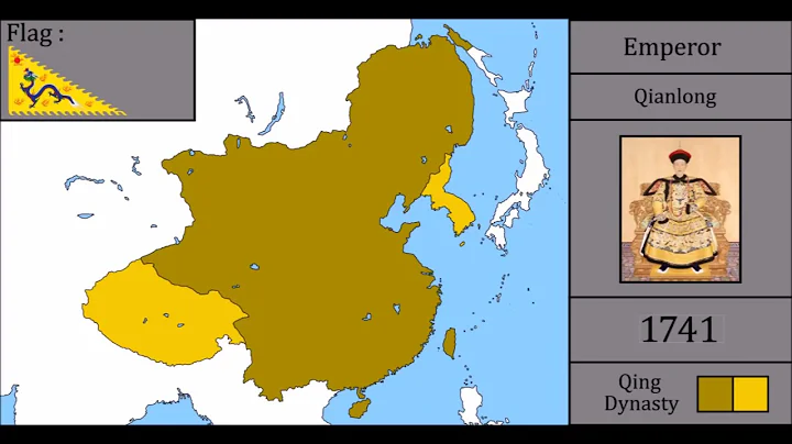
7. During the Qianlong Emperor Period (1735-1796)
During the Qianlong Emperor Period, the Junggar Khanate was in decline, and its Russia was precisely destroying Junggar. However, Emperor Qianlong took the lead. In 1755, he eliminated the Junggar Khanate and occupied the Western Regions. This is the first time the central dynasty of China has occupied this place after the Tang Dynasty. After that, Qianlong put down the rebellion of Amursana, Xiaohezhuo, and renamed the Western Regions to "Xinjiang", and set up General Yili to exercise jurisdiction there. Since then, the area of the Qing Dynasty has reached 13 million square kilometers. This data has been maintained. By 1858, about 100 years, this was the first phenomenon in Chinese history.
Situation during Emperor Qianlong
During Emperor Qianlong, the Junggar Khanate went into decline. In 1758, the Qing army marched into Ili and completely put down Junggar, and occupied the Western Regions. This is the first time the central dynasty of China has occupied this place after the Tang Dynasty.
In 1759, the Qing quelled the rebellion of the Great and Great States, and renamed the Western Regions to "Xinjiang" , Xinjiang returned to China after 900 years of the Anshi Rebellion, and General Yili was set up here. Jurisdiction.
Since then, the area of the Qing Dynasty has reached 13 million square kilometers. This data has been maintained until 1858. This is the first phenomenon in Chinese history, and the territory of the Qing Dynasty has reached its peak.
8, Qing peak territories and spheres of influence
At this time the territory: West from the Pamir Plateau, east and south of Lake Balkhash, Connecting to Central Asia; east of Japan Sea, Bohai Sea, Yellow Sea, Sakhalin Island, Taiwan and nearby islands; north of Gorno Altai, Sayan Mountains, WaixingAnling to the Sea of Okhotsk; to the Zengmu Shoal of the Nansha Islands in the south; to the Himalayas in the southwest, including Ladakh, with a land area of more than 13 million square kilometers.
It is a pity that the prosperity must decline. After Qianlong, the Qing dynasty began to decline. The so-called "heavenly dynasty" was finally insulted by the powers. Under the encroachment of the imperialist powers, the land continued to decline, lost more than 3.4 million square kilometers of territory, and eventually formed the territory of modern China.
Republic of China territory


![[Martial arts suspense] "Blood Forbidden Art" - DayDayNews](https://i.ytimg.com/vi/jicsddDULkg/hqdefault.jpg?sqp=-oaymwEcCOADEI4CSFXyq4qpAw4IARUAAIhCGAFwAcABBg==&rs=AOn4CLBevUdhcE54EsVak1-6yKZEEdEfhQ)