Nanwei Island is located 18.5 nautical miles southwest of the west reef of the Yinqing Group of Reefs, and is about 12 nautical miles east of the Riji Reef.. Nanwei Island covers an area of 0.15 square kilometers and is the largest island in the Nansha Islands occupied by Vietnam. Nungwei Island is located on a table-shaped reef platform, nearly triangular. The length of the east-west side of Nanwei Island is 350 meters, and the length of the hypotenuse from northeast to southwest is 750 meters. There are beaches around Nanwei Island, with reefs forming on the beaches, and sandbanks surrounding the low-lying reefs in the middle. There are natural waterways in the northeast of Nanwei Island that go deep into the island. The natural water channel is 14 meters deep.

Nansha Islands
Occupation situation of Nansha Islands
In 1946, the Chinese National Government sent the navy to accept Japanese occupation of Paracel Islands and Nansha Islands. In 1956, Taiwan China sent a navy to inspect Taiping Island and Nanwei Island in the Nansha Islands, and classified the Nansha Islands as the "Nansha Garrison Area." Since the People's Navy was relatively weak in the 1970s, no large naval warships were able to reach the Nansha Islands. , the People's Navy warships can only control the waters of the Paracel Islands. Although the Chinese Taiwan authorities have warships capable of reaching the Nansha Islands, at that time, the Chinese Taiwan authorities mainly focused on the Taiwan Strait . The main military forces were deployed in the Taiwan Strait and did not focus much on the Nansha Islands.
Nanwei Island
Nanwei Island
In 1973, South Vietnam began to occupy Nanwei Island and renamed Nanwei Island Changsha Island. After the reunification of North and South Vietnam in 1975, North Vietnam forgot to publicly recognize the Paracel Islands and the Nansha Islands as belonging to Chinese territory. North Vietnam began to take over South Vietnam and occupied six islands in the Spratly Islands (including Nanwei Island). North Vietnam further reclaimed the sea and built land on Nanwei Island, and established the first military command center of the Nansha Islands on Nanwei Island.
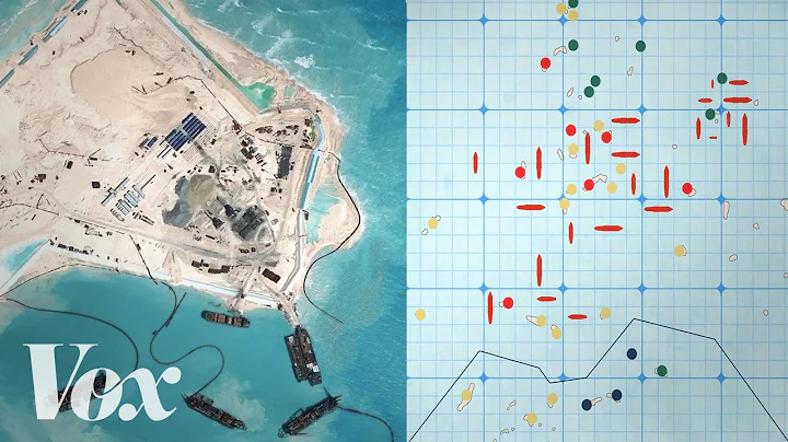
In 2016, Vietnam implemented a land reclamation plan on 10 islands in the Nansha Islands under its control. This includes Nanwei Island, which now covers an area of 0.15 square kilometers.
Expansion status of Nanwei Island
Nanwei Island
Vietnam is building an airstrip on Nanwei Island. The runway is approximately 600 meters long and is paved with concrete. Vietnam extended the runway to 1,000 meters after 2016. If Vietnam continues to extend the runway to 1,200 meters. Vietnam can take off and land maritime reconnaissance aircraft, transport aircraft and fighter aircraft on this runway. Vietnam has also built a helicopter pad , which can take off and land small propeller aircraft. A radio transmission tower has also been built on Nanwei Island to facilitate communication with mainland Vietnam.
Nanwei Island Airport
Nanwei Island has a tropical monsoon climate, and the plants on the island are tropical plants. The island has many seabirds and many eggs. Nanwei Island still retains the wells that Chinese fishermen used when they lived on Nanwei Island. The water in the wells is drinkable. Since Nanwei Island is the military command center of Vietnam's Nansha Islands, Vietnam has deployed more than one battalion of troops here, with a number of approximately 550 people.
The current situation of Nanwei Island
The sea area near Nanwei Island is a famous oil and gas rich area in the South China Sea. To the west of Nanwei Island is Wan'an Beach , and to the southwest is the Zengmu Sand Basin. This sea area is a famous oil and gas rich area in the South China Sea. Mainly distributed in the 100,000 square kilometers of sea area near Rijijiao.
my country’s exploration area in the South China Sea is only 160,000 square kilometers, and its proven oil reserves are 5.22 billion tons. According to exploration data, the oil reserves in the Zengmu Basin, Sha Basin, and Wan'an Basin in the South China Sea alone are 20 billion tons. This is also an undeveloped large-scale oil and gas area in the world. More than half of the amount is distributed over 2.1 million square kilometers in the South China Sea. On the sea. The South China Sea has always been known as the "Second Persian Gulf" and is one of the four major marine oil and gas accumulation centers in the world. The entire South China Sea oil reserve is about 30 billion tons, accounting for about 1/1 of my country's proven oil reserves. 3.
Oil field distribution
The Nansha Islands are rich in oil and gas resources. Southeast Asian countries have built offshore drilling platforms within China's nine-dash line.The Southeast Asian countries here are Vietnam, which is the most serious. Since Vietnam does not have oil exploration equipment, Vietnam has resorted to selling mining rights to Western companies. Since the end of the 1980s, 30% of Vietnam's economy has relied on oil development in the South China Sea. Oil development has created tens of thousands of job opportunities for Vietnam and also generated foreign exchange for Vietnam to purchase weapons to protect these offshore drilling platforms.
South China Sea oil distribution area
China oil distribution
Malaysia and Brunei are also learning from Vietnam and exploiting oil within the scope of China nine-dash line . Malaysia and Brunei once proposed the approach of "exchanging land power for sea power". Malaysia asked Brunei to give up its claim to sovereignty over the Limbang area. Malaysia handed over China's Nantong Reef to Brunei. The Brunei Sea obtained a Malaysian oil field for joint exploitation for 40 years. This oil field is located within the nine-dash line. Philippines has also stepped up its oil exploration work in the South China Sea. Although Indonesia has no direct conflict with China's territorial Nansha Islands, the exclusive economic zone in the waters of India's Natuna Group is within the scope of my country's nine-dash line. Indonesia also exploits oil within my country's nine-dash line.
Occupation of oil in the South China Sea


![China´s massacre in Spratly islands [real footage 1988] - DayDayNews](https://i.ytimg.com/vi/Uy2ZrFphSmc/hqdefault.jpg?sqp=-oaymwEcCOADEI4CSFXyq4qpAw4IARUAAIhCGAFwAcABBg==&rs=AOn4CLCyV8j-PNEGysR2961Nw780JjDX2A)